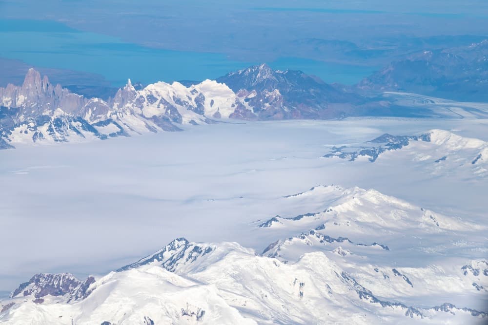
Patagonia's Southern Icefield
Patagonia's Southern Icefield
The world's third-largest ice cap, the Southern Icefield spans between Chile and Argentina and feeds approximately sixty glaciers, including the Perito Moreno and Grey.
Patagonia's southern icefield (Hielo Sur or Hielo Continental Patagónico, or Campo de Hielo Sur) is one of the most spectacular and underappreciated natural wonders on the planet. Nestled in the southern reaches of the Andes cordillera, on the border between Chile and Argentina, it represents a glacial treasure of exceptional ecological and geographical significance.
Characteristics
Patagonia's southern icefield is the world's 3rd-largest ice cap, after those of Antarctica and Greenland. It spans approximately 13,000–16,800 km² and stretches over 350 km in length. Nearly 80% lies in Chile, with the remainder in Argentina. This vast expanse of ice winds through the mountains of the Andes Cordillera, forming a natural boundary between Chile and Argentina. To date, approximately sixty glaciers branch off from Patagonia's southern icefield.
This ice cap feeds several major glaciers, notably Grey Glacier, Balmaceda and Serrano, and Pía in Chile, as well as Perito Moreno, Upsala, and Viedma in Argentina. Furthermore, it serves as an essential source for numerous hydrographic basins in the region. Glacier melt replenishes surrounding lakes such as Lago Argentino in Argentina and Lago Grey in Chile.
It is also worth noting that two volcanoes, Lautaro and Viedma, lie hidden beneath the icefield, adding a fascinating geological dimension to this frozen landscape. However, their difficult accessibility has limited research, making them among the least explored volcanoes in Chile and Argentina.
History
The history of Patagonia's southern icefield is intimately tied to that of its glaciers and the peoples who inhabited this remote region. Formed approximately 18,000 years ago during the last glacial period (locally called the Llanquihue glaciation), this ice cap has evolved over millennia, giving rise to the grand landscapes we know today.
The first peoples, notably the Tehuelches and Kawésqar, lived near these glacial expanses, adapting to extreme climatic conditions. These peoples developed a rich culture, often in harmony with this hostile environment.
Furthermore, during the 19th and 20th centuries, European explorers such as Argentine Francisco Pascasio Moreno and Italian Alberto María de Agostini contributed to mapping the icefield. The first aerial explorations of the ice cap were conducted by Gunther Plüschow between 1928 and 1929. Then, in 1943, the Chilean government used a military aircraft to photograph the region.
The Patagonian southern icefield was also the subject of territorial conflicts between Chile and Argentina, particularly regarding the precise demarcation of their borders. Although most of this region is now peacefully shared (1881 border treaty), certain undefined zones remain subject to diplomatic discussions. One particularly notable point is a 50 km stretch located between Mount Fitz Roy and Cerro Murallón, which remains the last unresolved border question.
Climate
Patagonia's southern icefield is subject to a cold and humid climate, influenced by particularly violent winds coming from the Pacific Ocean. Precipitation here ranks among the world's highest. The southern summer (November to March) is the best period to explore the icefield, as it offers milder climatic conditions and easier access.
Unique biodiversity in a harsh environment
Despite extreme climatic conditions, Patagonia's southern icefield and its surroundings harbor fascinating biodiversity. This unique ecosystem is adapted to low temperatures, violent winds, and abundant precipitation.
The surrounding national parks, such as Bernardo O'Higgins National Park in Chile or Los Glaciares National Park in Argentina, are sanctuaries for diverse wildlife. You can encounter:
- The Andean condor
- The huemul
- The Patagonian fox
Glacial rivers and lakes are also habitats for several fish species.
As for vegetation, it is limited by climatic conditions, but Nothofagus (southern beech) forests can be found in lower zones. Mosses and lichens dominate regions near the ice.
Visiting Patagonia's southern icefield requires careful planning due to its isolated location and limited access. It should also be noted that roads can be rough and weather conditions unpredictable. It is therefore essential to prioritize 4x4 vehicles or adapted transport. Here are the main options for reaching this region:
From Chile
Puerto Montt, the gateway to the Carretera Austral, is accessible by air from Santiago. From there, you can rent a vehicle or take a bus heading south to access points like Cochrane or Villa O'Higgins, near the glaciers. Journeys often include ferry crossings, particularly to reach isolated areas such as Bernardo O'Higgins National Park.
Moreover, Villa O'Higgins is a departure point for exploring Patagonia's southern icefield. Boat excursions allow you to approach glaciers such as O'Higgins Glacier or Steffen Glacier.
From Argentina
On the Argentine side, towns like El Calafate and El Chaltén serve as main bases for exploring Patagonia's southern icefield. El Calafate is accessible by air from Buenos Aires. It is also the gateway to Los Glaciares National Park, home to the famous Perito Moreno Glacier. Located further north, El Chaltén is a departure point for treks toward the glaciers of Patagonia's southern icefield, particularly those surrounding the Fitz Roy massif.
Via organized excursions
For adventurers wishing to explore remote areas like the Campo de Hielo Patagónico Sur, specialized guided tours are offered by both countries. These excursions often include boat crossings, ice treks, and camping in hard-to-reach regions.
Patagonia's southern icefield today
Like many other ice caps around the world, Patagonia's southern icefield is experiencing the effects of climate change. Numerous glaciers are retreating at an alarming rate, jeopardizing the ecosystems and local communities that depend on these water sources. Moreover, glacier melt contributes to rising sea levels and disrupts local hydrological cycles. Conservation of this region is therefore crucial for limiting the global impacts of climate change. Furthermore, the region also attracts researchers from around the world who study its glaciers to better understand the impacts of global warming and glacial dynamics.
Activities
Patagonia's southern icefield is a dream destination for adventurers and nature lovers. Its spectacular landscapes—featuring towering glaciers, jagged mountains, and turquoise lakes—offer unparalleled opportunities for exploration and outdoor activities.
Hiking and trekking
Hiking is one of the best ways to explore the glaciers of Patagonia's southern icefield. The most well-known glaciers are generally located within national parks, where numerous trails allow you to observe them from the shores. These walks offer the opportunity to witness ice melt at the end of the southern winter. It is important to equip yourself with appropriate clothing to face the region's climate.
Iconic trails allow you to discover the wonders of the region:
- The W Trek, in Torres del Paine National Park in Chile, is one of the most popular hikes, offering breathtaking views of the Grey and Dickson glaciers.
- Perito Moreno Glacier in Argentina can be explored on foot, with guided ice excursions.
Cruises and boat excursions
Cruises through fjords and across glacier-fed lakes offer another perspective on Patagonia's southern icefield. These expeditions often include stops to observe glaciers calving into the sea and view icebergs up close.
Interested in this visit?
We can include it in your personalised itinerary.